
Total Environment Butterfly of Dreams Location — Dommasandra, Sarjapur Road, Bengaluru 562125
Total Environment Butterfly of Dreams occupies 22.25 acres on the Sarjapura–Ambalipura Main Road (SH-35) at 12.882958 N, 77.746561 E, spanning two revenue villages — Thigalachowdenahalli and Dommasandra — in Sarjapura Hobli, Anekal Taluk, Bengaluru Urban, PIN 562125, with Muthanallur Cross 1.4 km away by road and the nearest operational metro station 12.4 km away. For location reading, Total Environment Down by the Water keeps the context local: commute anchors, school access, hospital reach, retail convenience, and last-mile movement decide whether the address works.
Every distance here is a road distance, measured on the OpenStreetMap road graph from the site pin on 15 August 2026. Straight-line figures appear only to expose a distortion and are labelled every time — this is one of the places in Bengaluru where the two measures disagree hard enough to reverse the order of landmarks.
Total Environment Butterfly of Dreams location sheet
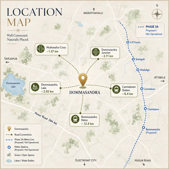
| Field | Value |
|---|---|
| Site pin | 12.882958 N, 77.746561 E |
| Revenue villages | Thigalachowdenahalli + Dommasandra |
| Hobli / Taluk / District | Sarjapura Hobli · Anekal Taluk · Bengaluru Urban |
| PIN | 562125 (not 560035) |
| Frontage road | Sarjapura Road / Varthur–Sarjapur Road, carrying ref=SH35 |
| Land / product | 22.25 acres · 1,188 apartments · 6 residential + 1 commercial tower |
| Approving authority | BDA — competent authority for this Local Planning Area |
| Status | Pre-launch · launch Q3 2026 · completion 28 February 2030 |
| RERA | Not registered as of August 2026 |
Where Total Environment Sarjapur Road Sits on the Corridor
Sarjapur Road is not one place. It is a 25 km south-east radial that changes character three times: an office corridor from Agara to Iblur, a dense residential belt from Kaikondrahalli to Carmelaram, and a peri-urban outer stretch from Dommasandra to Sarjapur town where the built fabric thins and the parcels get large. This project sits on the third stretch, and that is the most useful single fact about its geography — between Muthanallur Cross at 1.4 km and Dommasandra Junction at 2.1 km on SH-35, with Kodathi Circle (5.2 km), Kaikondrahalli (8.6 km) and Iblur (13.2 km) west, Sompura Gate (4.4 km) and Sarjapur town (6.6 km) east.
That puts the site outside the corridor's worst bottleneck rather than inside it. The Kaikondrahalli–Iblur stretch that generates the reported 75–90 minute end-to-end Sarjapur Road peak begins 8.6 km west. That is no advantage on its own, because every westbound city trip still has to clear it. What it changes is direction: a household working the Sarjapur Road / Carmelaram cluster at 5.9–8.1 km drives away from the jam, one working Bellandur or the ORR drives into it. Not the same address in practice, whatever the pincode says.
Land assembly at this scale stopped being possible west of Carmelaram a decade ago, which is why the eastern stretch carries the corridor's 20-acre-plus parcels while the mid-corridor is left with infill. The competitive set here is large-format and recent.
The Micro Address: Two Villages, Two Panchayats, One Taluk
"Dommasandra" alone is a half-address for this parcel, and the full one matters for anything a buyer has to file, verify or register.
| Layer | Position |
|---|---|
| Revenue villages | Thigalachowdenahalli (named in the land schedule) + Dommasandra |
| Gram panchayats | Yamare GP · Dommasandra GP |
| Hobli / Taluk | Sarjapura · Anekal — not Bangalore South, not Bangalore East |
| District / PIN | Bengaluru Urban · 562125 |
| Planning authority | BDA Local Planning Area |
| Civic tier | Gram panchayat / Anekal Taluk — outside the five Greater Bengaluru corporations |
Two independent checks confirm the village rather than assume it. Reverse geocoding the pin returns "Dommasandra, Anekal, Bengaluru Urban, Karnataka, 562125". Separately, both The International School Bangalore and Oakridge International School — the nearest top-tier schools, at 2.8 km and 1.7 km — geocode to Thigalachowdadenahalli, the revenue village in the project's own survey-number list.
On the planning authority the answer is BDA. The BDA Revised Master Plan 2031, Annexure-1 "Schedule of LPA of BDA", lists both parcel villages as Full Village inside the BDA Local Planning Area — Dommasandra at row 36, Thigalachoudadenahalli at row 54 — and BDA's Volume-4 defines PD 26, the "Dommasandra Special Development Zone". The Anekal Local Planning Area table begins one village east, at Muthanallur, Yamare and Sompura, and lists neither. Two competing attributions circulate: BMRDA, wrong because it is neither the LPA here nor a body that sanctions plans, and GBA, wrong because the site is outside the Greater Bengaluru planning area. BDA is the competent authority; that is not the same statement as "a plan has been sanctioned."
A pin correction is also worth publishing. Some listings carry a Plus Code decoding to roughly 12.8888, 77.6856 at Choodasandra — 12.6 km by road west of the real site, in a different taluk and PIN (560035). Reverse geocode, the SH-35 reference and the survey-number villages all agree on 12.882958, 77.746561. Use the coordinates; discard the Plus Code.
Straight-Line Versus Road at This Site: Four Inversions
Road distance divided by straight-line distance is the detour factor. Above about 1.6 the map is actively misleading. This site produces detour factors from 1.04 to 3.13.
Inversion 1 — the three "one kilometre" landmarks reverse completely
| Landmark | Straight-line | Road | Detour factor |
|---|---|---|---|
| Dommasandra Lake | 0.93 km — looks nearest | 2.92 km — is farthest | 3.13× |
| Dommasandra Junction | 0.95 km | 2.11 km | 2.22× |
| Muthanallur Cross | 0.97 km — looks farthest | 1.37 km — is nearest | 1.41× |
All three sit within 40 metres of each other in a straight line — 0.93, 0.95, 0.97 km — and the road order is the exact reverse. Muthanallur Cross is the road-nearest node to this site, not Dommasandra Junction, the opposite of what most listings say. And Dommasandra Lake is not a 0.5 km amenity: that is a straight-line figure from the site boundary to the nearest water's edge. By road the lake is 2.92 km, three times its straight-line distance and the largest distortion in the set.
Inversions 2 and 3 — the tech clusters and the inner city re-rank
| Destination | Straight-line | Road | What flips |
|---|---|---|---|
| Bagmane Constellation / World Technology Center | 12.19 / 12.60 km | 18.01 / 18.58 km | Look nearest of the clusters, drive farthest |
| Whitefield (Kadugodi) | 12.60 km | 15.07 km | Identical straight-line to Bagmane WTC, 3.51 km nearer by road |
| Central Silk Board | 14.06 km | 15.40 km | Looks farthest, drives nearer than either Bagmane park |
| Indiranagar vs Nexus Koramangala | 15.27 vs 15.75 km | 21.51 vs 16.69 km | Indiranagar looks nearer, drives 4.82 km farther |
| RMZ Ecospace vs Bellandur | 8.68 vs 8.68 km | 14.00 vs 11.54 km | Equidistant on a map; Ecospace 2.46 km farther by road |
| Cessna Business Park vs Kaikondrahalli | 8.00 vs 8.23 km | 12.37 vs 8.59 km | Cessna looks nearer, drives 3.78 km farther |
The cause is structural: there is no direct north-west road out of this pocket, so the trip runs out to the ORR and back in. Ecospace's 1.61 detour factor against Bellandur's 1.33 is the sharpest case — two destinations equidistant to the metre in a straight line, 2.46 km apart in a car.
Inversion 4 — the metro story is entirely tense-dependent
The nearest operational metro station is Bommasandra, 12.4 km by road. The nearest planned station is Muthanallur Cross, roughly 1.4 km. Dividing one by the other, 12.4 ÷ 1.4 ≈ 8.9× — a nine-fold gap between what exists and what is sanctioned. Every sentence about metro access here is either about a station 12.4 km away that runs today, or one 1.4 km away that does not exist yet.
One figure that must never be used
Routing to the "Electronic City Flyover" map node returns 24.59 km, because the router snaps to the access-controlled elevated carriageway and sends the trip the long way round. That number is a false artifact; Electronic City's real position is a range, given below.
Road Connectivity from Total Environment Butterfly of Dreams
Times are realistic ranges, re-based from uncongested routing floors onto observed corridor speeds — roughly 22–28 km/h off-peak and 12–18 km/h at peak inbound, 30–35 km/h outbound. Routing-engine minutes are not published here; Bengaluru does not achieve them. Peak is 08:00–11:00 inbound, 17:30–21:00 outbound, Monday to Friday.
| Destination | Road km | Off-peak | Peak |
|---|---|---|---|
| Muthanallur Cross (SH-35) | 1.4 | 4–7 min | 8–15 min |
| Dommasandra Junction | 2.1 | 6–10 min | 15–25 min |
| Kodathi Circle | 5.2 | 12–18 min | 22–35 min |
| Sarjapur town | 6.6 | 15–22 min | 25–40 min |
| Varthur / Kaikondrahalli | 8.6 | 20–30 min | 35–70 min |
| Bellandur Gate / Bellandur | 11.1–11.5 | 28–42 min | 55–90 min |
| Agara Junction / Iblur (ORR) | 13.1–13.2 | 35–48 min | 65–95 min |
| HSR Layout / NICE Road × Hosur Rd | 14.1–14.2 | 30–50 min | 45–100 min |
| Whitefield (Kadugodi) | 15.1 | 35–50 min | 60–90 min |
| ORR — Marathahalli / Silk Board | 15.2–15.4 | 38–55 min | 70–110 min |
| Koramangala | 16.2 | 42–58 min | 75–110 min |
| Attibele / NH-44 (Hosur Road) | 16.3 | 32–45 min | 50–75 min |
| MG Road / CBD | 28.1 | 60–80 min | 95–140 min |
Two rows deserve a second look. The ORR at Marathahalli carries a 1.62 detour factor — 15.2 km of road against 9.37 km straight-line, the worst ratio here. And Attibele on NH-44 is 16.3 km but only 50–75 minutes at peak, faster than Koramangala at the same distance, because it runs against the commuting grain.
Rail and Metro at Total Environment Sarjapur Road
Suburban and mainline rail — operational today
| Station | Road km | Realistic drive | Line |
|---|---|---|---|
| Carmelaram (Karmelaram) | 6.4 | 15–22 min off-peak · 25–40 min peak | Bengaluru–Salem (Hosur) line |
| Heelalige | 11.7 | 25–35 min · 40–60 min peak | Same line, further south |
Carmelaram is the nearest railway station at 6.4 km by road — one of the few points here with no inversion, nearest both by road and straight-line (5.19 km, a 1.23 detour factor), on the Bengaluru–Salem line via Hosur.
Metro — what runs, what is sanctioned, and the date that changed
| Line | Status, August 2026 | Nearest station to this site |
|---|---|---|
| Yellow Line (RV Road–Bommasandra) | Operational — opened 11 August 2025, 19 km, 16 stations | Bommasandra, 12.4 km by road · Electronic City, 13.7 km |
| Blue Line Ph 2A (Silk Board–KR Puram) | Not operational. Late-2026 target, 2027 slip flagged | Iblur / Bellandur, 11–13 km by road |
| Blue Line Ph 2B (KR Puram–Airport) | Not operational. Target December 2027 | — |
| Red Line / Phase 3A (Hebbal–Sarjapur) | Sanctioned, not under construction. Cabinet approval 6 December 2024; revised DPR April 2026; Union Cabinet approval pending; geotech surveys began January 2026 | Muthanallur Cross ~1.4 km · Dommasandra ~2.1 km |
The Sarjapur corridor line is Phase 3A, the Red Line — 36.59 km, 28 stations, 17 elevated and 11 underground. Its revised DPR cut the estimate from ₹28,405 crore to ₹25,485 crore, a reduction of ₹2,920 crore or 10.3%, and was resubmitted in April 2026. Union Cabinet clearance has not been granted; the January 2026 geotechnical surveys are the first on-ground activity, and no construction tender has been issued.
From the Sarjapur terminus the sequence runs Sarjapur, Kada Agrahara Road, Sompura, Dommasandra (station 4), Muthanallur Cross (station 5), Kodathi Circle, Ambedkar Nagar, Carmelaram, Doddakanalli, Kaikondrahalli, Bellandur Gate, Ibbalur and Agara, then on toward Hebbal. Siting is not final until tender, so 1.4 km and 2.1 km describe an alignment, not a built platform.
On the opening date, two figures circulate and only one is current. The October 2025 position targeted operations in December 2030. A mid-2026 DPR revision moved that to April 2033, carried by Deccan Herald, Asianet, Deccan Chronicle and ConstructionWorld in July 2026. April 2033 is the authoritative figure and the one this page uses. December 2030 survives only on aggregator pages that have not updated.
That correction matters for anyone underwriting this address. Stated completion is 28 February 2030; the metro's current target is April 2033 — roughly three years later. Any claim that possession and metro operations align here is wrong on current information, and checkable. Plan on driving or on Carmelaram at handover, and treat the Red Line as a possible resale-liquidity gain later in the 2030s, not a commuting asset at possession.
Airport Access
| Destination | Road km | Realistic off-peak | Realistic peak |
|---|---|---|---|
| Kempegowda International Airport (KIA) | 49.5 | 75–95 min | 105–150 min |
At 49.5 km of road against 35.24 km straight-line — a 1.41 detour factor — this is a long run, routed via the ORR or Hosur Road, through the city ring and out on Ballari Road. Budget 2.5 to 3 hours door-to-gate at peak. The 50-minute airport figure common in south-east Bengaluru marketing is an uncongested routing floor. Blue Line Phase 2B (December 2027) and the Bengaluru Business Corridor both change this materially; neither is operational.
Employment: Tech Parks Near Total Environment Butterfly of Dreams
| Park / campus | Road km | Off-peak | Peak | Occupiers / node |
|---|---|---|---|---|
| RGA Tech Park, Sarjapur Road | 5.9 | 14–20 min | 25–40 min | Chikkakanneli |
| Wipro Sarjapur Road campus, Doddakannelli | 8.1 | 20–28 min | 40–60 min | Wipro Ltd |
| Embassy Tech Village, Devarabisanahalli | 10.6 | 26–36 min | 50–80 min | Cisco, Sony, Cognizant |
| Cessna Business Park, Kadubeesanahalli | 12.4 | 30–42 min | 60–90 min | Cisco, Accenture |
| Prestige Tech Park, Kadubeesanahalli | 13.0 | 32–45 min | 60–95 min | JPMorgan, Oracle |
| Electronic City Phase 2, eastern edge | 13.7 | 32–45 min | 55–85 min | Infosys, Biocon, Tech Mahindra |
| RMZ Ecospace, Bellandur | 14.0 | 35–48 min | 65–95 min | Dell, Adobe, ANZ |
| ITPL / International Tech Park, Whitefield | 15.5 | 35–50 min | 60–90 min | TCS, IBM, Dell, Accenture |
| Electronic City Phase 1 core | 18.4–18.5 | 45–60 min | 70–105 min | Infosys, Wipro, HCL |
| Bagmane Constellation / World Technology Center | 18.0–18.6 | 42–60 min | 70–108 min | Mahadevapura |
The honest employment read is narrower than the marketing radius. This address is well placed for the Sarjapur Road / Carmelaram cluster — RGA Tech Park at 5.9 km and Wipro Doddakannelli at 8.1 km are 14–28 minutes off-peak, a real daily commute. It is acceptably placed for ORR–Bellandur at 10.6–14.0 km, where off-peak works and peak does not. It is not an Electronic City address and not a Whitefield address, though both fall inside the radius most listings draw.
Electronic City is also not one distance: its eastern edge is 13.7 km, the working Phase 1 core 18.4–18.5 km, and ITPL Whitefield at 15.5 km sits between the two. The claim that this corridor is closer to Electronic City than to Whitefield is true for one phase and false for the other. Name the phase, or publish the range.
Schools Near Total Environment Sarjapur Road
Schooling is the strongest amenity axis at this location, and it is not close. Four top-tier international schools sit within 3.5 km by road, all on the Varthur–Sarjapur Road spine the project fronts.
| School | Road km | Off-peak | Note |
|---|---|---|---|
| Oakridge International School | 1.7 | 4–8 min | Varthur–Sarjapur Rd, Thigalachowdadenahalli — the parcel's own revenue village |
| Inventure Academy | 2.3 | 6–10 min | Gunjur |
| The International School Bangalore (TISB) | 2.8 | 7–12 min | Varthur–Sarjapur Rd, Thigalachowdadenahalli |
| Greenwood High International | 3.5 | 8–14 min | Gunjur |
| Harvest International School | 6.3 | 14–20 min | Kodathi |
| Azim Premji University | 8.4 | 18–26 min | SH-35, Sarjapura |
| Primus Public School | 8.9 | 20–28 min | Chikkanayakanahalli |
| GEAR Innovative International School | 9.0 | 20–28 min | — |
| Indus International School | 10.1 | 22–30 min | SH-35, Modihalli |
Nine verified schools inside 10.1 km, four of them international-curriculum anchors inside 3.5 km, is a catchment that took two decades to form and that a newer corridor cannot reproduce. Oakridge at 1.7 km and TISB at 2.8 km both carry the project's own revenue village in their registered address — literal confirmation that the parcel sits inside the school belt, not beside it. Indus International is itself an inversion: 6.54 km straight-line, 10.07 km by road. Silver Oaks International appears on locality lists here but could not be geocoded to a verified corridor address, so it is omitted rather than guessed at.
Hospitals Near Total Environment Butterfly of Dreams
| Hospital | Road km | Off-peak | Peak |
|---|---|---|---|
| Motherhood Hospital, Sarjapur Road | 8.6 | 20–28 min | 40–60 min |
| Manipal Hospital, Sarjapur Road | 9.6 | 22–32 min | 45–70 min |
| Manipal Hospital Whitefield (formerly Columbia Asia) | 10.8 | 26–36 min | 45–70 min |
| Sakra World Hospital, ORR Marathahalli | 11.8 | 28–40 min | 55–85 min |
| Narayana Health City, Bommasandra | 14.3 | 32–45 min | 50–80 min |
| St John's Medical College Hospital, Koramangala | 16.2 | 42–58 min | 75–110 min |
This is the weakest axis after retail, and it should be stated plainly rather than padded with clinics. The nearest genuine multi-specialty tertiary facility is 8.6–9.6 km away — 20–32 minutes off-peak and 40–70 minutes at peak. For 1,188 apartments that is a real gap. It is not disqualifying: the Sarjapur Road cluster sits on the same westbound route every other trip takes, and Narayana Health City is a second axis south. But a household with elderly dependants should treat the peak figure as the planning number.
One geocoding trap leaks into published locality pages: a search for "Sakra World Hospital" returns a different, under-construction facility at Chellakere, 25.9 km by road, not the ORR flagship at 11.8 km. The figure above is the flagship.
Apartments Near Dommasandra, Sarjapur Road: What the Address Means Day to Day
Searches for apartments near Dommasandra Sarjapur Road and for flats in Dommasandra Sarjapur Road land on a stretch that is still in transition, and it is worth being plain about what that means. Dommasandra is a working junction settlement rather than a finished suburb: the retail is local, the footpaths are intermittent, and the civic fabric is panchayat-grade rather than city-grade. What it offers instead is parcel size, a lower entry into the corridor, and a position outside the Kaikondrahalli-Iblur bottleneck. Anyone searching Total Environment Dommasandra or Total Environment Sarjapur Dommasandra is looking at this same site — the project is marketed under the Sarjapur Road name but sits administratively in Dommasandra, Anekal Taluk.
Retail and Daily Needs Near Dommasandra
| Destination | Road km | Off-peak |
|---|---|---|
| Dommasandra Junction / Muthanallur Cross high street | 1.4–2.1 | 4–10 min |
| Total Mall, Sarjapur Road (Kasavanahalli belt) | 9.6 | 22–32 min |
| Market Square Mall · Nexus Koramangala · Forum Shantiniketan | 16.0–18.1 | 40–58 min |
Organised retail is the weakest amenity axis at this address. Day-to-day needs are served — the Dommasandra and Muthanallur Cross high street at 1.4–2.1 km carries groceries, pharmacies, banking and hardware — but everything above neighbourhood grade is 9.6 km or more, and true mall-format retail is 16–18 km, a 40 to 58 minute drive each way off-peak.
Two malls that appear on locality pages here, Central Mall Sarjapur and Park Square Mall, could not be verified at a Sarjapur-corridor address and are omitted rather than published; phantom amenities are common in this belt. The realistic read is a schooling-and-employment location with thin organised retail — the gap most likely to close on its own as the base east of Carmelaram fills in, but it has not closed yet.
Honest Trade-Offs at This Location
SH-35 congestion is the standing cost of this address. Reported peak runs 75–90 minutes end-to-end on Sarjapur Road, and 45–60 minutes for the 20 km Agara–Dommasandra leg alone. Six bottlenecks are named on this corridor — Wipro Signal, Iblur Junction, the Kaikondrahalli Lake stretch, Bellandur, Dommasandra Circle and Carmelaram. Two of the six sit directly on this site's city-bound route.
There are active roadworks on the frontage. The nearest road snap point to the site is tagged highway=construction in the OpenStreetMap extract — consistent with the reported Sarjapur Road widening, and a signal that the frontage is a live construction environment. The widening is the upside; the years of disruption are the cost.
Water is the material risk. Cauvery Stage V, at ₹4,336 crore, serves the 110 villages added to BBMP limits in 2007. Dommasandra is in Anekal Taluk, outside those limits, so it is not in the Stage V service area. BWSSB's grid covers the 575 sq km core, the 110 villages add roughly 225 sq km still being connected, and everything beyond that 800 sq km remains borewell- and tanker-dependent. Extension to Anekal is stated policy intent, not delivered infrastructure. This project is designed for self-sufficiency rather than a municipal connection, and its filed numbers say so: 2,202 KLD consumption, 1,982 KLD wastewater, a 2,020 KLD SBR plant, a 1,020 cu m sump and 22 recharge pits. Run the plant arithmetic — 2,020 KLD installed against 1,982 KLD generated is 38 KLD of headroom, or 1.9% — and it is sized to its design load with very little slack, which makes commissioning and maintenance the question rather than spare capacity. Supply here is borewell, tanker and in-project treatment and recharge, with no confirmed BWSSB Cauvery connection.
Civic jurisdiction is panchayat, not corporation. BBMP has been replaced by the Greater Bengaluru Authority and five city corporations covering roughly 712 to 721 sq km depending on the source. Reverse geocoding this site returns "Dommasandra, Anekal, Bengaluru Urban" with no city-corporation tier at all — unlike Bellandur and Varthur, which return "Bengaluru East City Corporation". Expect panchayat-grade delivery for roads, water and solid waste, khata and property-tax nuances, and slower upgrade cycles.
The on-site nala. A tertiary nala crosses the site with a 15 m buffer and roughly 220 m of realignment proposed. Recharge is engineered here, but the taluk has no assured surface-water supply.
RERA. The project is not registered as of August 2026. A full parse of the Karnataka RERA registry returned no entry under any Total Environment promoter entity, and all Anekal-taluk rows were enumerated separately to rule out a differently-named vehicle. Under section 3 of the Real Estate (Regulation and Development) Act 2016, marketing and sale are unlawful until a project is registered. No number should be quoted, because none exists.
Infrastructure Pipeline: Status, Not Promises
| Project | Status, August 2026 | Timeline | Relevance to this site |
|---|---|---|---|
| Metro Phase 3A, Red Line (Hebbal–Sarjapur) | Sanctioned by Karnataka Cabinet 6 Dec 2024. Revised DPR (₹25,485 Cr) resubmitted April 2026. Union Cabinet approval pending. Geotech surveys started Jan 2026; no construction tender | Construction targeted 2027; operations targeted April 2033 | Highest-impact item. Stations at Muthanallur Cross (~1.4 km) and Dommasandra (~2.1 km) |
| Bengaluru Business Corridor / Peripheral Ring Road | Under tender. BDA project, 73.5 km access-controlled. Package 1 (19.8 km, ₹3,348 Cr) drew bids 8 May 2026; three packages still tendering | Full corridor 2029–30 | Alignment passes 1.2–1.8 km straight-line from the site — access upside and acquisition uncertainty at once |
| STRR / Satellite Town Ring Road (NH-948A) | Near complete. Four of six packages done; remaining two targeted Sep and Nov 2026. Hoskote–Hosur leg held by a ~650 m rail overbridge | 144 km operational by late 2026 | Runs via Sarjapura, Attibele and Anekal — this site's own hobli. Access via Sarjapur town (6.6 km) |
| Blue Line Phase 2A (ORR) / 2B (Airport) | Neither operational; 2A late-2026 target with 2027 slip risk | 2A late 2026 / 2027 · 2B Dec 2027 | 2A: nearest station Iblur–Bellandur, 11–13 km. 2B: airport relief on a 49.5 km run |
| Sarjapur Road widening + Dommasandra grade separator | Partially reported, low confidence. ~7 km of widening in two stages between Iblur and Dommasandra, with grade separators including at Dommasandra; a flyover package reportedly paused over contractor and funding issues. Sourced to secondary coverage, not a government notification — treat as unconfirmed | Unconfirmed | Directly affects the frontage; the highway=construction tag is the on-ground signal |
| ORR–Sarjapur signal-free / elevated corridor | Proposal only | None | Not committed; should not be priced in |
The STRR is the near-certain item — mostly built, passing through this hobli, changing regional rather than city connectivity: Hosur, Attibele and the eastern industrial belt get closer without touching the Sarjapur Road commute. The Red Line is the high-impact uncertain one, sanctioned by the state but not the Union Cabinet, no tender issued, target already moved once. The Peripheral Ring Road is the one to watch on the ground: an access-controlled corridor 1.2–1.8 km away is a genuine change in access, and an alignment that close is a live acquisition question until it is built. Within the same total-environment Bengaluru portfolio, Total Environment Yelahanka helps readers judge whether brand comfort is also matched by location, format, and budget fit.
What This Location Is, and What It Is Not
It is a schooling and Sarjapur-cluster employment address on a large parcel — four international schools inside 3.5 km, two registered in the project's own revenue village, the RGA and Wipro campuses at 5.9 and 8.1 km, and 22.25 acres on a stretch of corridor that still has land. It is not a metro address today, with the operational network 12.4 km off. It is not a corporation address — Anekal Taluk, gram panchayat civic delivery, outside the Cauvery Stage V service area. And it is not an Electronic City or Whitefield address, whatever the radius maps suggest.
Read all of it on road distances. At this pin the map inverts the order of the three nearest landmarks, sends the nearest-looking tech cluster on an 18.6 km detour, and makes a lake 2.92 km away look like a 0.93 km amenity. The measured numbers are the only ones that survive contact with a car.
Contact the Total Environment Butterfly of Dreams desk
Ask for the brochure, the cost sheet when it is issued, floor plates and a site visit for Total Environment Butterfly of Dreams.
Total Environment Butterfly of Dreams location — questions
Which authority approves the plans, and is this under BBMP or the Greater Bengaluru Authority?
Plan sanction sits with the Bangalore Development Authority. BDA's Revised Master Plan 2031, Annexure-1, lists both parcel villages as Full Village inside the BDA Local Planning Area — Dommasandra at row 36, Thigalachoudadenahalli at row 54 — and BDA Volume-4 carries planning district PD 26, the "Dommasandra Special Development Zone". BMRDA is wrong twice over: wrong planning area, and it does not sanction plans. BBMP was dissolved on 2 September 2025 and replaced by the Greater Bengaluru Authority and five city corporations, and this site falls outside all five — civic services run through gram panchayat and Anekal Taluk administration. Naming BDA as competent authority is not a statement that any plan has been sanctioned.
How is the Sarjapur Road area for daily living?
Two honest halves. The strength is schooling — four top-tier international schools inside 3.5 km by road on the SH-35 spine: Oakridge International 1.7 km, Inventure Academy 2.3 km, The International School Bangalore 2.8 km, Greenwood High 3.5 km, two of them in the parcel's own revenue village. The weakness is congestion and everything above neighbourhood grade: peak times run 75–90 minutes end to end, two of the corridor's named bottlenecks sit on this site's city-bound route, the nearest multi-specialty hospital is 8.6–9.6 km and mall-format retail 16–18 km. Nambiar District 25, the only large branded scheme in the same locality at 1.56 km, faces the same trade-off.
What is the status of the Sarjapur Road metro, and when will it open?
Phase 3A — the Hebbal–Sarjapur Red Line — cleared the Karnataka Cabinet on 6 December 2024, and a revised DPR costing ₹25,485 crore was resubmitted in April 2026. Union Cabinet approval is still pending, geotechnical surveys began in January 2026, and no construction tender has been issued. Two opening dates circulate; the earlier is superseded by a mid-2026 revision to April 2033, carried by Deccan Herald and Deccan Chronicle in July 2026. April 2033 is the current figure — roughly three years after the stated possession, so do not underwrite this address on the assumption that the two align, and treat station siting as provisional until tender.
How far is Carmelaram station, and what else is measurable from the site?
Carmelaram is the nearest railway station at 6.4 km by road, on the Bengaluru–Salem line, with Heelalige at 11.7 km. It is nearest by both road and straight line — unusual at this address. Electronic City is not one distance: its eastern edge is 13.7 km while the working Phase 1 core around the Infosys and Wipro campuses is 18.4–18.5 km, which places ITPL Whitefield between the two. Any single figure much beyond 18.5 km is a routing artifact, not a drive.
Where is Dommasandra, and which taluk and district is it in?
Dommasandra sits on the Sarjapura–Ambalipura Main Road (SH-35) in south-east Bengaluru, between Varthur and Sarjapur town. Administratively it is in Sarjapura Hobli, Anekal Taluk, Bengaluru Urban district, Karnataka, PIN 562125 — not 560035. It is a census town, so "rural or urban" has no clean answer: an urbanising village belt with a gram panchayat, not a city-corporation ward. The parcel straddles two revenue villages and two gram panchayats — Thigalachowdenahalli under Yamare GP, Dommasandra under Dommasandra GP — which makes "Dommasandra" alone a half-address here.
Which metro station is nearest, and is Bommasandra the same as Dommasandra?
The nearest operational station is Bommasandra on the Yellow Line, 12.4 km by road; the nearest planned are Muthanallur Cross at about 1.4 km and Dommasandra at about 2.1 km on Phase 3A — roughly a ninefold gap between what runs and what is drawn. Bommasandra and Dommasandra are two different places: Bommasandra is on Hosur Road near Electronic City, Dommasandra on the Sarjapur corridor. Search engines themselves substitute one for the other, so if a listing claims an already-operating station nearby, check which it means.